Fort Frances
To Du Vernet, Fort Frances was the place where a young man had gotten into “trouble with a widow.” It was also, however, the oldest European settlement of continued existence west of Lake Superior. Located where the Rainy Lake narrows to the Rainy River, Fort Frances began in 1731 as Fort Saint Pierre, a small fur trade outpost. In the late eighteenth century, the North West Company established another settlement, Fort Lac La Pluie, nearby, which would become the basis of the modern town. Following the North West Company’s merger with the Hudson’s Bay Company in 1821, Fort Lac La Pluie became a Hudson’s Bay Company post. In 1830 it was renamed Fort Frances in honour of Frances Ramsay Simpson, the new wife of the Hudson’s Bay Company’s Governor.
Fort Frances’s growth accelerated from a hamlet to village following the signing of Treaty 3 or the Manidoo Mazina’igan (“Spirit Paper” or “Sacred Document”) in 1873. The Canadian government used the Treaty to appropriate Ojibwe lands in northwestern Ontario for the use of white settlers, triggering a new wave of Euro-Canadian settlement. Fort Frances became the region’s centre for colonial policy towards the local Ojibwe peoples and served as the base for the region’s Indian Agent for “Agency 1.”
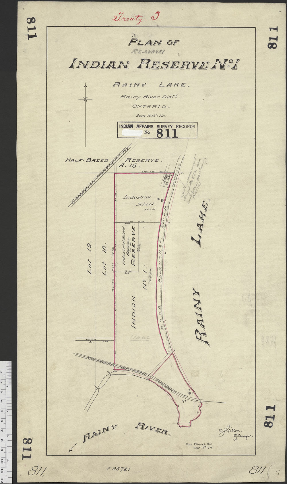
Agency Indian Reserve 1 and Fort Frances
Near Fort Frances was the traditional governmental and meeting centre of the regional Ojibwe. During the nineteenth century the Ojibwe gathered in the area, near Chaudiere Falls, for large Grand Council meetings. These councils served as the centre for regional Ojibwe decision-making, addressing issues such as land allocation, trade and relations with white traders and settlers.
In 1873, Treaty 3 allocated the land near Fort Frances for the Agency Indian Reserve (IR) 1. Agency IR 1 was not surveyed for any one particular Indian Band but instead as the centre for the region’s Indian agent. Within a decade of signing Treaty 3, the government prohibited the Ojibwe and other Indigenous people from using the Agency IR 1 grounds for its traditional governmental and ceremonial purpose. The Department of Indian Affairs saw the traditional Grand Councils as a threat to its control and sought to suppress its activity.
Beginning in 1904, the town of Fort Frances applied to the Department of Indian Affairs to use Couchiching Point, then part of Agency IR 1 land, for park purposes. Since the reserve was not set aside for any single Indian Band, Indian Affairs said that a surrender could only be obtained after securing the approval of all the Indian Bands within the agency. The Indian Agent pursuing the case ignored this instruction and instead obtained an agreement to surrender from only four Indian Bands, none of which included any Rainy River Ojibwe or any other band that had been part of the Fort Frances Agency. Nonetheless, Indian Affairs allowed the land to be leased to Fort Frances in 1910 at a rate considerably less than its actual value. The four First Nations that were involved in the surrender of Agency IR 1––the Couchiching, Stanjikoming, Naicatchewenin, and Nicickousemenecaning First Nations–– have been involved in the administration of the reserve since 1957.
The Fort Frances Mission
The Anglican Church Missionary Society established a mission near Fort Frances that took the town’s name, acting as a subdivision extending between Fort Frances and the general Indian Reserve. Robert Phair oversaw the Fort Frances mission, also called Alberton, beginning in 1874. According to Phair, the mission’s Salteaux residents were unanimously opposed to Christianity and, rather than convert, took the opportunity to criticize the government’s failure to fulfill its Treaty 3 obligations. Due to its lack of perceived success, the Church Missionary Society closed the mission towards the end of the nineteenth century.
Today
Combined with nearby canal building, emigration trade, and commercial fishing and logging, Fort Frances and its surrounding settlements grew so fast that fur trading was no longer feasible. By the early 20th century, Fort Frances had left behind its fur trading past and on April 3 1903, incorporated, beginning its development as a modern city. Today, Fort Frances is the third largest community in Northwestern Ontario. The Rainy River First Nations and the Couchiching First Nation are among the Ojibwe nations near the city today. Especially close to the Fort Frances is the Agency 1 reserve, which is shared between the Couchiching, Naicatchwenin, Nigigoonsiminikaanmng, Couchiching and Mitaanjigamiing First Nation communities. These First Nations are currently in an extended court battle with the Canadian Government over land claims in the area.
Sources