Image: “Map of the Province of Ontario Canada.” Department of Agriculture, 1908. Courtesy of the University of Toronto Map & Data Library (call no. G3500 2755 1908 B-2 Rare).
ONE DIARY, MANY STORIES:
MAPS OF THE LAND AND WATER
The map gallery includes historical maps of the land and water of Treaty 3 territory visited by Frederick Du Vernet. With the Mirador Image Viewer, you can zoom into each map to take a closer look.
Instructions:
1. Click here to learn how to use the image viewer.
2. Click on each map to view a larger version.
MAPS
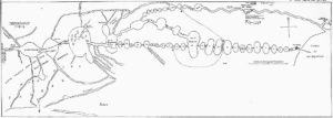
1. “Map of Boundary Waters region, including Lake Superior, Kaministiquia River, Rainy Lake, Lake of the Woods, and Lake Winnipeg, drawn by Native guide Auchagah for La Vérendrye sometime around 1730.”
Available through Wikimedia commons.
Unlike the others in this Gallery, this particular map was drawn up by a Cree man named Auchagah, who conducted trade at Fort Kaministiquia (now Fort William) at the outskirts of Thunder Bay. It shows a schematic of the waterways between Lake Superior and Lake of the Woods, including the Rainy River between Rainy Lake and Lake of the Woods. Auchagah drew this map at the behest of French fur trader and explore Pierre Gaultier de La Vérendrye, who sought a route to the “western sea.” According to the Geographicus blog, Auchagah’s map eventually served as the basis for Jacques-Nicholas Bellin’s map of North America, published in 1743.
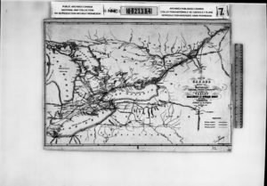
2. “Map of Canada shewing the Railway’s completed in progress and projected to accompany the Canada Railway and Steam-boat Guide.” Maclear & Company Liths., 1856.
Courtesy of University of Toronto Map & Data Library (call no. NMC21384)
Published in 1856, four years before Du Vernet was born, this map shows existing and anticipated transportation routes in southern Ontario, including train lines. Because the map is a scanned microfiche, lines completed and lines in progress cannot be easily distinguished. In Episode 2: The James Taylor Rogers’s Story, Du Vernet talks about a conversation with James Taylor Rogers on his way east from Toronto to the junction at Carleton Place. This line is not present or even anticipated in this map, showcasing the significant increase in transportation infrastructure in Canada from the middle of the 19th century to the early 20th century.
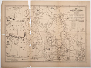
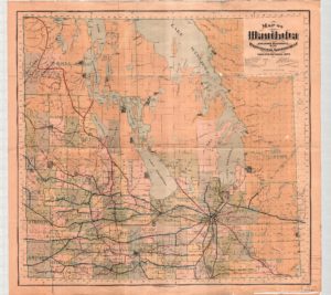
3. “Map of the Province of Manitoba and part of the district of Keewatin and North West Territory: shewing the townships & settlements: drawn from the latest gov. maps, surveys & reports for ‘The Prairie Province’.” Alex R. Craig Steam Lith., 1876.
Courtesy of University of Toronto Map & Data Library (call no. G3540 1876)
This map shows some of the territory west of the Rainy River, with part of the Lake of the Woods appearing in the bottom right corner. Lake Winnipeg features in some of the stories involving Jeremiah and Mary Johnston. However, this map of 1876 does not achieve the same cartographic precision as map 8 below, published in 1903. Lake Winnipeg is significantly slimmer in this map and the coast does not receive the same level of detail. However, some of the same landmarks appear, albeit with some variation. The Bloodvein River, where the Jeremiah and Mary Johnston travelled, is here called the Blood River, while Jackhead appears to be called Jackfish. The Canadian Pacific Rail line appears to cross the Red River, unlike Du Vernet’s experience recorded in Episode 20: Moving Further West. But as Du Vernet claims, the decision to divert the railway to Winnipeg contributed to its growing significance as a city.
4. “Map of Part of Keewatin shewing Dominion Land Surveys to 31st December, 1876.” Dominion Land Office, 1877.
Courtesy of Thomas Fisher Rare Book Library (call no. G3513 .K42 1877 Maps large)
Similar to map 6, this “Map of Part of Keewatin” shows the results of land surveys done in the Rainy River area. That this map is sanctioned by the Canadian Department of the Interior is indicated by their crest, located above the map’s title in the bottom left corner. From afar, the reservations at Long Sault, Manitou Rapids, and Little Forks are quite visible, empty rectangles set against the finely graded plots of European settlers.
5. “New railway and commercial map of Ontario.” Compiled and drawn by S.R.G. Penson, 1887.
Courtesy of University of Toronto Map & Data Library (call no. G3521 .P3 1887 Rare)
Like map 2 above, this one records rail lines. But since it was published 31 years later, there are significantly more, including a line the goes up to Carleton Place from Toronto, as described in Episode 2: James Taylor Rogers’s Story. However, his map also includes an inset at the bottom right corner, inscribing the railway line as it extends from above the north shore of Lake Huron, west beyond Lake Superior and even Rat Portage. In Episode 3: On the Train, Du Vernet mentions passing stations at Biscotasing, Missinabie, Jack Fish Bay, Wabigoon, Vermillion Bay, and finally Rat Portage.
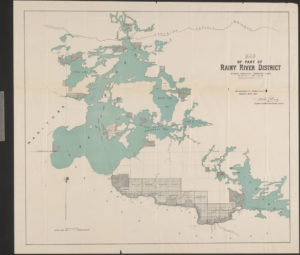
6. “Map of Part of Rainy River District: showing surveyed townships along Rainy River,” from Frank Yeigh, The Rainy River District, Province of Ontario, Canada: An Illustrated Description of its Soil, Climate, Products, Area, Agricultural Capabilities and Timber and Mineral Resources, together with the Laws and Information Pertaining to Free Grants and Homesteads, Third Edition, Ontario Dept. of Crown Lands, 1894.
Courtesy of Thomas Fisher Rare Book Library, University of Toronto (call no. cap 03502).
This map vividly displays how the Dominion Government sequestered the Treaty 3 Ojibwe of Rainy River to small reservation lands out of the way of European settlers. Several small Ojibwe reservations can be witnessed along the north shore of the Rainy River, surrounded by much larger clusters of plots laid out for future settlers. Du Vernet intermittently visits these reservations throughout his journey. Toward the mouth of the Rainy River are Hungry Hall (14 and 15). Further east along the river are other numbered reservations: Long Sault (“Indian Reserve 13” and “Indian Reserve 12”); and Manitou Rapids (“Indian Reserve 11”); Little Forks (“Indian Reserve 10”). Du Vernet passes by Hungry Hall and Long Sault, on his way to Little Forks, which he in Episode 4: Along the River. Du Vernet rode the rapids at Long Sault by canoe, in Episode 8: Down the Rapids, held a Christian worship service at Long Sault in Episode 11: The Morning Service, and he visited the missionary school at Manitou Rapids, receiving resistance from Chief Great Hawk in Episode 6: The Story of Great Hawk. These reservations feature in additional Episodes as well. The Rainy River had also become the border between Canada and the US, with Minnesota on the southern side of the river. This map also shows the Canadian Pacific Railway line, which Du Vernet rode to Rat Portage, recounted in Episode 3: On the Train.
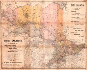
7. “New Ontario including the districts of Nipissing, Algoma, Sault Ste. Marie, Thunder Bay, Fort William, Port Arthur, Lake Nepigon, Rainy River, Alberton, Fort Frances, Rat Portage, Keewatin, Wabigoon, Dryden.” Rand McNally and Company, 1902.
Courtesy of University of Toronto Map & Data Library (call no. G3500 2217 1902 B-2 Rare)
Both sides of this map are worth viewing, showcasing a colonial logic of land use, its value, and occupancy, around the time that Du Vernet was visiting the Rainy River. Utilizing visual projection of the land of Ontario, the front advertises the rich natural resources of Canada available to industrious settlers; 160 acres of “free land.” The map does not tell its viewers that this land is Treaty 3 territory. The back of the map provides, mainly through text, useful information for settlers who wish to occupy and work the land pictured on the obverse. The Rainy River is one of four districts mentioned (along with Nipissing, Algoma, and Thunder Bay), which can be accessed through Port Arthur and Fort William, Rat Portage, Fort Frances. Du Vernet passed through Rat Portage, as the map suggests, as he came to and went from Rainy River (see Episodes 3, 4, 19, & 20).
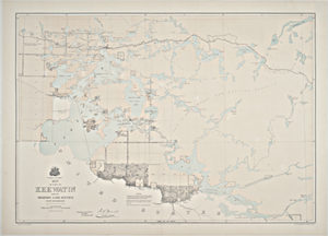
8. “Map of Manitoba published by the authority of the Provincial Government.”
Manitoba Department of Agriculture and Immigration, 1903.
Courtesy of University of Toronto Map & Data Library (call no. G 3540 633 1903)
This map of Manitoba, published in 1903 shows the land to the west of Lake Winnipeg, including Jack Head, where Jeremiah Johnston was a Catechist for four years shortly after his time as a voyageur of the Sudan (see Episode 1: Jeremiah Johnston’s Story). Across from Jack Head, is the Bloodvein River, where Du Vernet says that Jeremiah travelled with his wife, Mary Johnston. Further south in Lake Winnipeg is Hole River, where Mary Johnston is said to have saved a man from drowning with one finger; Du Vernet mentions this in Episode 1 and Episode 10: Mrs. Johnston’s Stories of Saving the Drowning.
Just south of Lake Winnipeg are the towns of East and West Selkirk located on either side of the Red River. In Episode 20: Moving Further West, Du Vernet says he must cross the River to get from East Selkirk to West Selkirk, citing decisions of the Mackenzie government not to put a rail line between the two towns. This map depicts the results of that decision, and Du Vernet’s experience of it, showing railway lines very clearly as they move roughly south toward Winnipeg.
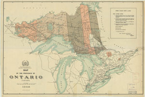
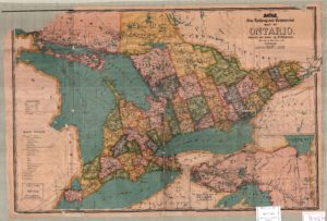
9. “Map of the Province of Ontario Canada.” Department of Agriculture, 1908
Courtesy of the University of Toronto Map & Data Library (call no. G3500 2755 1908 B-2 Rare)
Like map 7 above, this map advertises “Cheap Crown lands” and “free grants” throughout the land designated by the Canadian government as Ontario. The Rainy River District is included with Districts of Wabigoon, Parry Sound, and Thunder Bay, advertised as possessing “good markets,” “fertile soil,” and “invigorating climate,” in order to entice settlers. The land along the Rainy River itself is called “good agricultural land,” with no indication that it belongs to the Ojibwe.
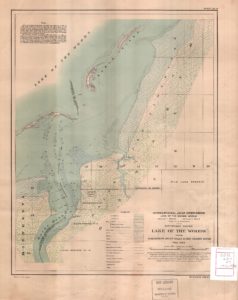
10. “Southern Shore Lake of the Woods, from Northwest Angle Inlet to Big Grassy River, 1913-14,” part of “Watershed of the Lake of the Woods.” U.S. Geological Survey, 1912.
Courtesy of University of Toronto Map & Data Library (call no. G3512 .L34 C315 500 1928)
In Episode 4: Along the River, Du Vernet recounts that after taking the S.S. Keenora through the Lake of the Woods, he reached the mouth of the Rainy River at around 8 am on Thursday, July 14, 1898. This map, interested in showing the watershed from the Lake of the Woods also marks Hungry Hall as “Indian Reserve No. 14” and “Indian Reserve No. 15,” which Du Vernet passed through on his way to and from Rainy River in Episode 4 and Episode 11: Into the Late of the Woods. The survey for this map was completed shortly after Du Vernet passed through the mouth of the Rainy River.
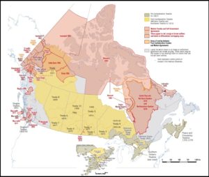
11. “Indian treaties, Canada.” Canada. Dept. of Indian Affairs and Northern Development, 1961.
Courtesy of University of Toronto Map & Data Library (call no. G3401 .E1 8870 1961)
Although published several decades after Du Vernet’s time at the Rainy River, this map divides Canada according to its various Treaties with Indigenous Nations. The Rainy River falls on Treaty 3 land, bordered by Treaty 1 to the west, Treaty 5 to the northwest, Treaty 9 to the northeast, and Robinson-Superior to the east. For more information on the history and implications of Treaty 3, see here.
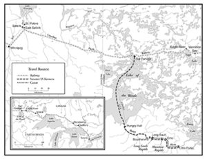
12. “Map of Du Vernet’s journey to Rainy River I, 1898.” Cartographer: Douglas Fast, 2011.
This map, drawn up for Pamela Klassen’s The Story of Radio Mind (Chicago, 2018), isolated Du Vernet’s journey told in his diary, including three different modes of transportation: rail; steamer boat, and canoe. This map is useful to have on hand whenever Du Vernet mentions the places he visits or his mode of transportation.
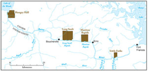
13. “Map of Du Vernet’s journey to Rainy River II, 1898.” Cartographer: Douglas Fast, 2011.
This map was also drawn up for Pamela Klassen’s The Story of Radio Mind (Chicago, 2018), and clearly labels the towns and reserves that Du Vernet visited during his journey. The reserves include Hungry Hall, Long Sault, Manitou Rapids, and Little Forks. The towns include Boucherville, Emo, and Fort Frances.
14. “Canadian Treaties Map.” Map produced by GIS and Cartography Office, Department of Geography, University of Toronto for the exhibit Canada By Treaty: Negotiating Histories, co-curated by Heidi Bohaker, James Bird and Laurie Bertram, 2017.
Created for a pop-exhibit at the University of Toronto, this map shows the shifting landscape of treaties over time across Canada. Treaty 3 is clearly identified in yellow with other post-Confederation treaties. Make note of the legend at the top right, explaining how to differentiate historic treaties made before and after Confederation (1867), the present locations of Reserves, and modern agreements made after 1973.